


Foot
The Gizia ravine
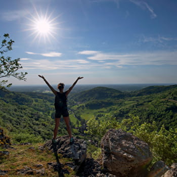
This three-kilometre-long valley ends in a retreat with cliffs 150 metres high. It benefits from an exceptional natural setting with the presence of species such as the peregrine falcon or the Gizia saxifrage.
From the "Châtel" post, head towards "Larot" on the road that climbs. It leads to the crosses, "Larot" and to the "Belvédère du Chanelet" (from the Gizia cross, a viewpoint on the retreat and on the Bresse). 100 m further on, turn left onto the path and find the road. It leads on the left to "La Pionnée".
Continue to the left until you reach "Chanelet Village".
Go down the path (direction "Gizia"). Cross the D 134 twice and arrive in the valley. Go past the church and the town hall and follow the river on the D 134 for 250 m.
At "Gizia", take the path on the left through the woods, then continue up the road.
At "Croix de Châtel", leave the path on the right. Before the cross, climb the hairpin path on the left. Cross the avenue of plane trees and reach the car park.
> Possibility to extend the itinerary by taking the Grand circuit Seigneurs et Templiers (12th century atmosphere where castles, knights and Templar monks live again) (total route of difficult level, 5 h, 17.4 km, 615 m difference in height): at the post "La Pionnée", go to the right towards "Petit Moiria", then "Les Grands Prés". After "Château de Rosay", climb gently towards "Chapelle des Templiers", pass Graveleuse, descend towards "Les Closets". Go up again to "Combe Pernet", pass "Chatey à Lait", "La Fontaine". Leave Chevreaux (12th century castle) at "Croix des Morts", continue towards "L'Oratoire" and "Croix de Châtel". From there, continue along the circuit to "Châtel".
Brochures edited by Montagnes du Jura
We tell you more